Initial Flight Data From the DC Plane Crash Shows Conflicting Altitude Readings Between Aircrafts

Yahoo!
Conflicting preliminary data raises questions about aircrafts' altitude at time of midair crash

Preliminary data from the deadliest U.S. aviation accident in nearly 25 years showed conflicting readings about the altitudes of an airliner and Army helicopter when they collided near Reagan National Airport in Washington, killing everyone aboard both aircraft, investigators said Saturday.

Left
Yahoo!
Just The News
Cause of deadly airline-helicopter crash remains unclear amid conflicting flight altitude data

Data from the flight recorder for the commercial American Airlines jet shows the craft's altitude was at 325 feet, plus or minus 25 feet, when the crash took place, according the to National Transportation Safety Board.

Middle
Just The News
Daily Mail
Altitude reading from DC plane crash could explain how it happened

Data recovered from the American Airlines plane and Army helicopter crash in DC revealed a key discrepancy in their altitude readings that may offer an explanation for the tragedy that left 67 dead.

Right
Daily Mail
Sponsored

Western Razor Co.

Get 5% off now with code FREESPOKE! Ditch the disposables and switch to an American-made safety razor and get a better shave.
View More

News Results

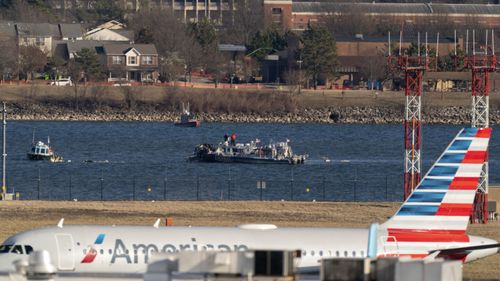
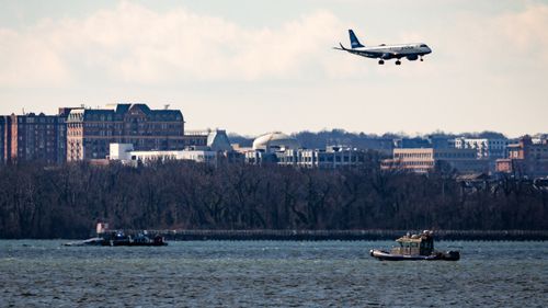
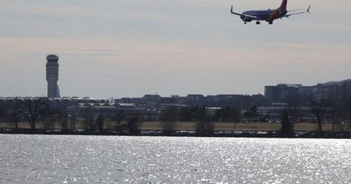
DC plane crash data show conflicting altitude readings between plane and helicopter
Readings have been compared from the black box recovered from American Eagle flight 5342 and the air traffic control tower about the Black Hawk helicopter
News Article Image
Preliminary DC plane crash flight data shows conflicting altitude readings: investigators
Data from the American Airlines flight showed an altitude of 325 feet, plus or minus 25 feet. Data in the control tower showed the maximum allowed altitude for helicopters in the area. The roughly 100-foot altitude discrepancy in the data has yet to be explained. The data is being retrieved from the helicopter's back box, which is taking more time because it became waterlogged.
News Article Image
Data from the deadliest U.S. air accident in 24 years show conflicting altitude readings
Preliminary data from the deadliest U.S. aviation accident in nearly 25 years showed conflicting readings about the altitudes of an airliner and Army helicopter when they collided near Washington.
News Article Image
Washington plane crash mystery as recovered altitude data baffles investigators
Flight 5342 was carrying 64 people when it crashed into the Potomac River. Data retrieved from the jet's flight recorder shows it was at 325ft (99m) The figure is at odds with the 200ft (61m) which the Black Hawk was placed at.
News Article Image
D.C. crash investigators focus on altitude and vision quality of helicopter crew
Investigators are looking into whether the pilots from the Army's Black Hawk helicopter experienced vision impairment while flying in the dark skies. The Black Hawk may have been flying higher than it should have been, said representatives from the National Transportation Safety Board. The Wednesday night impact sent passengers into the icy waters of the Potomac River.
News Article Image
Army helicopter’s altitude seen as factor in DC crash probe
The flight path of an Army helicopter before it collided with an American Airlines Group Inc. passenger jet is emerging as a key line of inquiry in the probe of the midair tragedy that killed 67 people. Investigators probing the accident have confirmed that the military aircraft was flying at an altitude above the upper limit for helicopters in the area near Ronald Reagan Washington International Airport.
News Article Image
Plane pilots made last-minute heroic move to save passengers but it was too late
Pilots' final words: "That is something that we will get you more detail on" Investigators find conflicting readings on the altitudes of the airliner and helicopter at the time of the collision. AA5342's flight recorder puts its altitude at 325 feet, give or take 25 feet. Control tower data shows the Black Hawk helicopter at 200 feet.
News Article Image
Conflicting preliminary data raise questions about aircrafts' altitude at time of plane-helicopter crash
Preliminary data raise questions about aircrafts' altitude at time of plane-helicopter crash. Data from jet’s flight recorder showed its altitude as 325 feet, plus or minus 25 feet. Data in the control tower, though, showed the Black Hawk helicopter at 200 feet.
News Article Image
NTSB: Conflicting Altimeter Data Retrieved After Midair Collision Near Washington
Investigators have found conflicting altimeter readings from the control tower data of the Black Hawk military helicopter and the passenger jet that collided over Washington on Jan. 29. Preliminary altimeter data do not match the events on the night of the deadly accident, NTSB officials told reporters on Feb. 1.
News Article Image
Sponsored

Western Razor Co.

Get 5% off now with code FREESPOKE! Ditch the disposables and switch to an American-made safety razor and get a better shave.
View More